User:Zaz/Regions: Difference between revisions
< User:Zaz
Jump to navigation
Jump to search
Want an adless experience? Log in or Create an account.
(Created page with "=Regions, subregions, and how to find them= There are 8 regions and 22 subregions in botw. We want some way to verify where their borders go. For regions we are out of luck, c...") |
No edit summary |
||
| Line 21: | Line 21: | ||
==Dont even get me started on which subregions are in which region== | ==Dont even get me started on which subregions are in which region== | ||
* Most are obvious, but some are not. Is Hyrule Ridge part of Hebra or Central Hyrule? How about Lake Hylia? Or Great Hyrule Forest? | * Most are obvious, but some are not. Is Hyrule Ridge part of Hebra or Central Hyrule? How about Lake Hylia? Or Great Hyrule Forest? | ||
==Work done so far== | |||
[[File:User-Zaz_Regions01.png]] | |||
Border colors: | |||
* Orange - Eldin Canyon | |||
* Blue - Hyrule Field | |||
* Cyan - Lanayru Wetlands | |||
* Lime - West Necluda | |||
* Dark Green - East Necluda | |||
* Yellow - Mount Lanayru | |||
* Black - Lanayru Great Spring | |||
* Violet - Akkala Highlands | |||
* Pink - Lanayru Sea | |||
* Maroon - Necluda Sea | |||
* Grey - Anomalies | |||
Revision as of 09:56, April 2, 2017
Regions, subregions, and how to find them
There are 8 regions and 22 subregions in botw. We want some way to verify where their borders go. For regions we are out of luck, currently, but subregions we can find. The trick is in the save file names. Each save gets labeled with the region the save is taken in, so all we need to do is run along each subregion border and check what it says on the save file screen.
Notes
- You dont need to actually save, just look at the save file screen for the name.
- Save file position doesnt update unless link is on solid ground. This means the subregion label wont update if you paraglide, swim, fall, climb, slide, or stand on a cryosis pillar. I'm unsure about running and walking.
- Sometimes the border is a hard border. Moving one meter will switch labels, moving back will switch it back. Other times the border is soft. Backtracking can be done quite a long way before the label updates.
- Some locations have their own small region. Shrines, Villages, Settlements - they all have a hard border against the greater subregion they are in.
- Some other locations also have their own small region. For example, the spring of wisdom, and lanayru east gate. I don't know why, or if the border is hard or soft.
- For some regions you can use the temperature meter to check the region border. Mount Lanayru is cold, and along the entire border against East Necluda the border follows the temperature gague. It will go down when you enter the mountain, it will go up if you go back across to necluda, even if the distance is just a few meters. You can also see the difference when snow turns to rain etc.
- Sometimes there seems to be a slight lag in the label update. I haven't been able to pinpoint the difference.
- Most hard borders seem to go along roads, or natural borders like rivers.
- Appearently, a road can belong to one sub region, the left side to another, and the right side to yet another. Example: The road from Ternio Trail to Akkala Highlands belong to Akkala Highlands, but the left side of the road is in Eldin Canyon while the right side of the road - and the cliffside - belongs to Lanayru Great Spring.
- Some regions can have very contorted shapes. Lanayru sea for example, reaches all the way into lanayru bay.
Gathering and presenting the data
- I don't know how we should best present this data. I could see it as a layer on the map, but I mainly want it to be able to assign correct regions and subregions to all locations.
- In either case, gathering the data is currently a manual process. At some point we probably need to convert the data into polygons using the same coordinate system the map does if we want to script the updates to location pages. Painful.
Dont even get me started on which subregions are in which region
- Most are obvious, but some are not. Is Hyrule Ridge part of Hebra or Central Hyrule? How about Lake Hylia? Or Great Hyrule Forest?
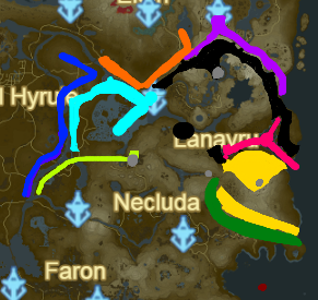
Work done so far
Border colors:
- Orange - Eldin Canyon
- Blue - Hyrule Field
- Cyan - Lanayru Wetlands
- Lime - West Necluda
- Dark Green - East Necluda
- Yellow - Mount Lanayru
- Black - Lanayru Great Spring
- Violet - Akkala Highlands
- Pink - Lanayru Sea
- Maroon - Necluda Sea
- Grey - Anomalies


