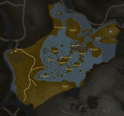
Lanayru Wetlands
| This article is a stub. You can help the Zelda Dungeon Wiki by expanding it. |
"These extensive wetlands cover a broad plain to the southwest of Zora's Domain. There are several islands throughout the shallow lake that are connected with crude bridges. There are the remains of a ruined village on the large island in the middle of the wetlands."
Games | ||
Location | ||
The Lanayru Wetlands is a location found in Breath of the Wild and Age of Calamity
It is a district, largely formed by moorland, in the westernmost part of Lanayru province, which both major rivers from Lanayru Great Spring flow into.
The Wetlands are bordered by the Hylia River to the west, Crenel Peak to the north-west, Zelo Pond to the north, Inogo Bridge over the Zora River to the north-east, the Rutala River to the east, Quatta's Shelf & Telta Lake to the south, and Nabi Lake to the south-west.
Locations
Breath of the Wild
- Bannan Island
- Boné Pond
- Goponga Island
- Goponga Village Ruins
- Kincean Island
- Lanayru Tower
- Linebeck Island
- Mercay Island
- Millennio Sandbar
- Molida Island
- Moor Garrison Ruins
- Rikoka Hills
- Shrine Island
- Wes Island
- Wetland Stable
- Zauz Island
Shrines
Age of Calamity
Gallery
Link paragliding over the Wetlands


